
Mount. Si GPS Data
So on my hike Tuesday, I wore my Garmin Forerunner 305. It kept giving me funky readings, so basically I just used it to keep track of how long I was on the mountain. When I got back it said that I had gone something like 6 miles when the trail is actually 4 up and 4 back. Today when I downloaded it, it said that I had gone 9.31 miles. But the track actually looks pretty accurate and the elevation is definitely there. I put the elevation proflle below the map . . . as you can see, it’s a pretty good workout! Now I just hope my legs recover enough for the Tour De Pierce this Sunday! Click on the map below to be transported to Motionbased to see the rest of my workout details. Unfortunately I forgot my heart rate strap, so that wasn’t recorded.
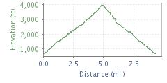
Mt. Si Elevation Profile